A BRIEF HISTORY OF KIMPTON
The
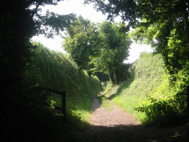
present Parish of Kimpton extends from Peters Green in the north, to the Cross
Keys Public House, Gustard Wood in the south, and from Pool House in the west to
Kimpton Mill in the east. It covers an area of approx. 3700 acres, almost
entirely farming land; only about 170 acres of woodland remain.
2000 years ago the entire area would have been covered with forest since the
heavy clay soil was ideal for tree growth. Early men with their primitive flint
axes found tree-felling slow and laborious; so they tended to keep to the more
open tracts of country. It is therefore not surprising that no trace of early
man has yet been found in the Parish.
In these times an active river would have flowed down the Kimpton Valley,
entering the River Mimram near the present Kimpton Mill.
Roman Times (back to top)
The Romans occupied this
country for nearly 400 years from 43 A.D. onwards. They brought with them a
very advanced culture. One of their largest settlements was at Verulamium (now
St. Albans) and remains of villas have also been excavated at Welwyn and
Hitchin.
We have no evidence of Roman dwellings in the Parish, although in 1815 workmen
widening a road in Priors Wood found a dark coloured urn containing a hoard of
230 silver republican and imperial coins. The oldest of these was minted in 2
B.C. and the most recent 104 A.D.
A Roman chariot bell is also supposed to have been found at Blackmore End. This
may have been a relic from one of the bloody encounters between Boudicca
(Boadicea) Queen of the Iceni tribes of East Anglia and the Roman Governor
Suetonius.
The Romans are renowned for their roads, which connected the military centres
of occupation. They were straight and well drained, with a surface of compacted
gravel or other local material, up to 50 feet wide on major routes. Two of
these roads by-passed Kimpton:
WATLING STREET, London to Chester, running through St. Albans and Dunstable. .
ERMINE STREET London to Lincoln, running through Hertford and Royston.
In the last 10 years archaeologists have discovered a network of minor Roman
roads, built for civil rather than military purposes. These roads often
followed pre-Roman tracks, modified by the Roman engineers. Three such routes
passed through Kimpton:-
 Hall
Lane
Hall
Lane
ST. ALBANS - ICKLEFORD
near HITCHIN, via edge of Gustard Wood Common - Kimpton Hall Farm - Kimpton
Memorial Hall - Cuckolds Cross.
COLEMANS GREEN (Near SANDRIDGE) - BALDOCK, via rear of Ayot St. Lawrence Church
- spine of hill down to Kimpton Mill (called Laver Ayotbury)
AYOTBURY (Near WELWYN) - FRIARS WASH, via the high ground to the north of the
Lea Valley, passing behind Cross Keys Public House - then changing direction
slightly to follow the now disused road which ran up to 1874 from Blackmore End
to Raisins Farm.
Traces of these roads are difficult to see to the inexperienced eye. Over many
centuries remains of the original surface have been covered by a layer of
topsoil, and often all traces have been obliterated by ploughing or building.
Scorch marks sometimes indicate the route across fields, especially if they can
be viewed from the air. In the dry summer of 1959 clear scorch marks
appeared in front of Heron's Farm at the far corner of Gustard Wood Common.
Local archaeologists excavated a trench to section the road, which proved to be
18 feet wide. Regrettably a modern barn now stands on the site.
Over the years the Roman soldiers had gradually been called away from Britain
to fight on other fronts and by 410 A.D. the British were left to defend
themselves as best they could from the warlike Scots from Ireland, and the
Picts from Scotland. (back
to top)
1st Thousand Years (back
to top)
Once the Romans had left
there was no central organisation to finance or carry out repairs to the roads,
which were anyway an easy means of access to invaders. So the roads fell into
disrepair, and were quickly overgrown forming low ridges and hedgerows which
were often used as boundary markers in later times. Our own Parish boundary
partly follows two of these roads.
For the next 500 years our island was continuously under attack from Scots,
Picts, Vikings, Danes, Angles, and the Saxons from northern Germany. Following
in the wake of the Saxon invaders however came the Saxon immigrants who were
mainly farmers. They began to clear the land and cultivate it, slowly working
their way up the river valleys. So the first settlers in Kimpton probably
appeared during this period, possibly in the vicinity of Kimpton Mill. They
founded self-contained communities, building their huts in an elevated position
overlooking their fields. (back
to top)
11th Century and Doomsday Book (back
to top)
By this time the
prehistoric river that flowed down the Kimpton Valley, had already been reduced
to little more than a brook. Gradually the farmers cleared the forest on the
banks until by the beginning of the 11th century they had reached the present
village site.
Most of this is pure supposition as apart from the Anglo-Saxon Chronicles
(which don't mention a place as small as Kimpton) there are virtually no
written documents.
We do know however that in King Edward the Confessors reign just before the
Norman Conquest, the Manor was owned by a woman - Aelveva, the widow of Aelfgar
the Earl of Mercia who died in 1062. His father, Leofric, had a very famous
wife Godgifu, or as she is better known, the legendary Lady Godiva.
Aelveva's children were also prominent historical figures. Edwin, the eldest
son, had become Earl of Mercia on his father's death. Morcar was made Earl of
Northumbria in 1065 and her daughter, Edith, took as her second husband, Harold
II who was King of England for a few months in 1066, before his defeat and
death in the battle with the Normans at Hastings.
This battle marked the start of the Norman Conquest. By Christmas 1066 the
chief barons of. England had submitted after the area around London had been
ravaged, and William the Conqueror was crowned in Westminster Abbey.
William confiscated the lands of the Saxons. Many of the manors were handed
over by the King to the leaders of this army in return for military support.
Kimpton was one of the many estates given to Odo, the warrior-Bishop of Bayeux,
the King's half-brother. Odo in turn sub-let the manor to "Ralf"
probably Ralf de Curbespine, who also owned other manors in Kent. Kimpton was
assessed at 2 Knights Fees, that is to say, Ralf would be responsible for
supplying 2 knights for about 2 months each year to serve in the King's army.
In 1085 William ordered a national survey to be carried out so that "he
might know what obligation each landowner owed him." The information was
gathered together and summarised at Winchester into the "Doomsday
Book." The entry in folio 134b refers to Kimpton, and an 18th century
translation of the Norman French in the document would read as follows:
"Ralf held Kamintone of the Bishop of Bayeux, in the half hundred of Hiz
It was rated at 4 hides. The arable is 10 carucates, in demesne are 2 and a 3rd
may be made. There are 2 frenchmen born, and 12 villeins with 2 bordars having
7 carucates, there are 3 cottars and 5 serfs. Meadow for 6 oxen, wood to feed
800 hogs, and a mill of 8/- rent by the year, in the whole value it is worth
and was worth £12 by the year, in the time of King Edward £I5. Alveva the
mother of Earl Morcar held this manor."
What sort of picture can this information give us of Kimpton?
Each shire or county was divided into Hundreds - Kimpton was one of the manors
in the Half Hundred of Hiz or Hitchin.
The population of Kimpton was 24 excluding women and children. The area of
forest which had been cleared for cultivation was about 480 acres - this would
be equal to an area on the north bank of the brook, ½ mile wide stretching from
Claggy to Kimpton Mill. The area would be divided into two huge open fields
each in turn divided by low banks into narrow strips of about ½ acre (this was
reckoned to be the area a plough team of 8 oxen could till in one day). Ralf,
the Lord of the manor, held about 270 of these strips called the demesne. It is
unlikely he actually lived here as he owned larger manors in Kent. His steward
and bailiff would manage the estate here, possibly the two frenchmen mentioned
in the Domesday Book.
There were 12 villeins each owning about 50 strips which were scattered over
the fields to ensure that each man had a share of the good and bad land alike.
In return each man would have to work on the Lord's demesne with his own plough
for 2 or 3 days per week, perform cartage duties, and give extra help at sowing
and harvest time.
The 5 bordars and cottars would have a small holding of up to 5 acres in return
for helping on the Lord's land.
The 5 serfs were the lowest order of society, with virtually no land and they
were probably employed as swineherds in return for the barest necessities of
life. Much of the manor was still forest, sufficient to keep 800 pigs.
Each year one field would be sown and the other left fallow. There was a little
meadowland in the valley bottom near Kimpton Mill to provide some hay for the
oxen, which would otherwise graze on the fallow, stubble, or forest waste.
The villeins would grind their corn at the Lord's water mill, probably located
in a similar position to the present one.
The village would be a group of low single room hovels, without the refinements
of windows or chimneys, accommodating both family and animals. The Domesday
Book gives no details of the siting of Kamintone, but a location near the
present village green would afford a reasonable view over their fields down the
valley. No mention is made of a church, but Domesday only seems to document
churches which were of economic importance to the community. So there may have
been a crude, wooden, barn-like church standing on the site of the Parish
Church.
The manor seems to have declined in value between 1066 when it was worth £15
and 1086 when it was worth only £12. This may have been caused by a reduction
of the workforce due to military service in these troubled times. Another
factor was the bad weather in 1082, which according to the Anglo-Saxon
Chronicle caused a great famine.
Besides the actual Manor of Kimpton, there was another area of cultivated land,
probably on the south side of the Kime Valley covering about 200 acres. This
was an appurtenance of the Manor of Pirton and came under the control of Ralf
de Limesi, Lord of that manor and founder of Hertford Priory. Some 200 years
later this area was to form the independent Manor of Bibbesworth.(back
to top)
12th - 17th Century and Variations of Name (back
to top)
By
the 12th century, despite the attractions of the Crusades, the Lord of the
Manor became more interested in his land and the hope of increasing his estates
by marriage, than in the knight service for which the land had originally been
granted. From 1159 Scutage was introduced, which was a cash payment in lieu of
knights service, to enable the King to hire soldiers for his army.
Gradually the villeins began to pay rent for their strips instead of working on
the Lord's demesne. By the late 14th century due to the financial burden of the
100 years war with France, the mortality of the Black Death in 1348 when about
one third of the population was wiped out, and the general agricultural
depression, Lords of the Manor began to lease their demesne for rent to gain
financial security. These new tenants formed a new class in society - the
prosperous Yeoman Farmer.
The only documentary information about Kimpton during this period comes from
odd references on exchequer and court rolls regarding payment of taxes or
tithes, and the granting or transfer of property.
The Name "Kimpton'' is derived from the Saxon "Cyma-tun,"
meaning "homestead of a person called Cyma." It is interesting to see
how the original village name, Cyma's tun, changed through the centuries until
reaching its present day form - Kimpton:
·
11th century Kamintone
·
12th century Cumintone
·
13th century Camentone, Cumitone,
Cumytone, Cementone, Kimitone, Kymetone, Kymitone, Kymmetone, Kumyngtone,
Kemintone, Kemytone.
·
14th century Kymyntone, Kymyntone,
Kemitone, Kemmyngton, Kemmynton, Kemynton.
·
15th century Kympton
·
16th century Kompton
·
17th century Kempton
During the 17th and 18th
centuries wealthy men acquired large country estates, buying up adjacent manors
or obtaining them through marriage. The Hoo family of St. Pauls Walden had
purchased the Manor of Hocknenhanger in 1596, and the land passed by
inheritance to Susan Hoo who married Jonathan Keate. By 1670 he had purchased
the manors of Parkbury with Leggats, and Bibbesworth and almost the whole of
the east end of the Parish had become part of the "Hoo Estate,"
centred at Hoo End. In common with the practice of the time, a new grander
house was built: Kimpton Hoo.(back
to top)
17th - 20th Century (back
to top)
In
1732 the "Hoo Estate" was sold to the Brand family, who later through
marriage succeeded to the Baronetcy of Dacre. The 22nd Baron Dacre's brother,
Henry Bouverie William Brand, had a distinguished Parliamentary career, serving
for 11 years in the Treasury, and was Speaker of the House of Commons from 1872
-1884. On his retirement from the House, he was created 1st Viscount Hampden,
and on his brother's death in 1890 became the 23rd Baron Dacre. The Baronetcy
is at present in abeyance between the two surviving daughters of the 26th Lord
Dacre. (Kimpton Hoo was demolished in the 1950's. For a few years the
outbuildings were used as a chicken farm; today the site is a small
housing estate. - C.T.)
In 1938 the Hoo Estate of the 4th Viscount Hampden was purchased by the Oxford
University, using money donated to them by the late Lord Nuffield.
The oldest houses in the parish date back to the late 16th and early 17th
century. They include Little Priory, The White House, and the Craft Centre in
the High Street, and the following farmhouses: Tallents, Ramridge, Stoneheaps,
Kimpton Hall and Kimpton Mill.
At the beginning of the century there were many ale houses and pubs in the
village:
·
Black Horse
·
Two Brewers
·
The Goat
·
The Greyhound
·
The Posting House
·
The White Horse
·
The Boot
These
last two are the only pubs remaining in use today (back
to top)
Churches and Records (back
to top)
By far the oldest
building in the village is the Parish Church of St. Peter & St. Paul. The
stone church was started at the beginning of the 12th century, with a simple
nave and a small chancel, built around the previous wooden church which was
later removed. By the end of the 12th century, in order to meet the needs of a
growing parish, narrow aisles were added, the arcades formed, and the chancel
was lengthened to its present size. These arcades are probably the oldest part
of the church that can be seen today. Each generation has enlarged or
beautified the church in some way. A low tower was added in the 15th century
and was subsequently raised to its present height in 17th century. The lower
part of the tower is at present being re-built, the 15th century mortar holding
the flints in place has crumbled making the south face unstable. Bad enough to
prevent us ringing the bells! Since its formation in 1984 the Restoration Trust
has spent £200,000 on structural repairs. This is our generation's contribution
to the building, together with the Kimpton Guild of Change Ringers who in 1981
masterminded the replacement of the old bell frame and the purchase of 2 new
bells to give the church a ring of 8 bells.
The capitals of the
pillars are one of the most important architectural features of the church,
being good examples of early English work (1190 - 1200). At this time the
introduction of the chisel to the masons range of tools, made possible the
carving of simple forms of foliage. In the 15th century the South Aisle was
widened to its present size, and the Tower, Porch and South Chapel added. The
latter is thought to have been built by the Bibbesworth family, and at a later
date became known as the Dacre Chapel. In 1710 it is recorded that the church
contained several 15th century monumental brasses. Today only a partial brass
remains. It shows a young girl with long unbraided hair and is probably
Margaret Bibbesworth.
The first documented Vicar of Kimpton, Nicholas de Spondon was installed by the
Bishop of Lincoln in 1235. In the 18th century the vicarage was sited at `The
Grange' at west end of village. In 1883 a new vicarage was built north of the
church, complete with coach house and was designed to accommodate a butler,
footman, coachman, house servants and 3 gardeners. The present vicarage at 11
High Street, was originally the bakery, and we now share the Vicar with the
neighbouring parish of Ayot St Lawrence.
The Wesleyan Methodist Church on the village green was
built in 1870 and the Sunday School Hall was added in 1907.
In Peters Green a school was erected in 1877 which was used as a Chapel on
Sundays. It was opposite the Bright Star P.H. This ceased to be used in 1959,
and is now a private house. The altar is the one now used in the parish church.
The original Union Chapel at Perry Green built in 1886, had to be demolished a
few years ago due to rot in the woodwork. Since then a much smaller Baptist
Chapel has been built on the same site.
For the past 400 years, records of baptisms, marriages and burials have been
kept in the Parish Church registers, the earliest entry being made in 1559.
These books, which are now held by the County Records Office in Hertford,
contain a valuable record of Kimpton social history. Names such as Bigg,
Chalkley, Hill, Ivory, Lawrence and Wells appear before 1700, and families
bearing the same name are still resident in the village. The registers also
record items of economic and local news; for instance, sharp price increases
are recorded between 1800 - 1801 when wheat rose from 16s Od to 23s Od per
bushel and poor families found it difficult to survive. Another reference in
1826, shows how a family weekly income of lOs Od was spent (and this didn't
include rent, clothes and firing!):-
|
|
s |
d |
|
½ bushel flour @ 6/-, 3 loaves @ 2/6 |
8 |
6 |
|
½ lb candles @ 3½d, ½qtr. flour @ 4¾d |
|
8¼ |
|
1lb pork @ 9d, ¼ lb soap @ 2d |
|
11 |
|
¼ oz tea @ 1¼ d, sugar and butter 6d |
|
7¼ |
|
TOTAL |
10 |
8¼ |
Today
many of the old farms have been joined together to provide more economic units,
and due to mechanisation only employ a hand full of men. The farm houses still
remain, most have been extensively altered, and some are now private dwellings,
but most still carry the name of the original farmer 600 years ago. (back to top)
Village
Halls (back to top)
Before
the last war, Kimpton Village Hall was the long narrow building in the High Street
next to The Wick. This had been inadequate for a long time and in 1943 a
committee was formed to raise money for a new hall as a memorial to the men of
Kimpton who had fallen in two world wars. In 1956 Viscount Hampden opened the
Memorial Hall sited in Hall Lane.
|
|
|
|
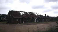
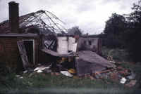
Photographs courtesy Jon Marsh
Early on the morning of 4th July 1981 the building was almost totally destroyed by a fire, started by an arsonist.
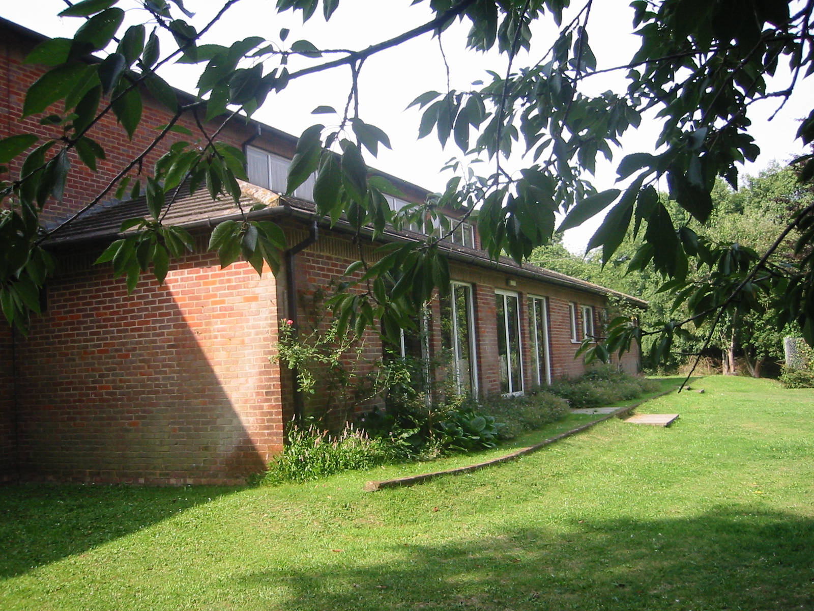
After
an enormous effort by everyone in the village and the village organisations,
funds were raised to build a bigger and better Memorial Hall, which was opened
by Queen Elizabeth the Queen Mother on 1Oth July 1983. It had taken just 2
years, - a fantastic achievement.
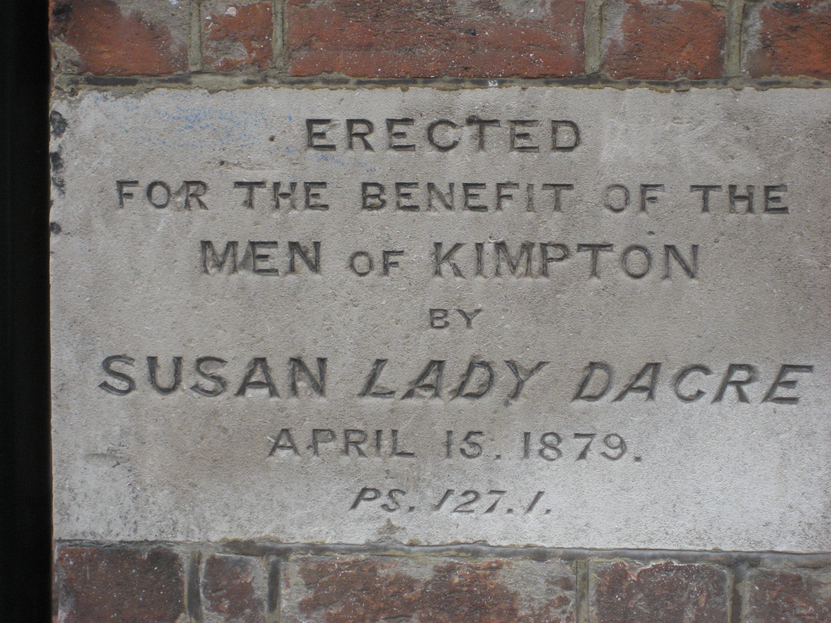
The
Dacre Rooms, in the High Street opposite Church Lane was erected in 1879 by
Susan Lady Dacre, "for the benefit of the men of Kimpton". During the
last twenty years it has been used by the Football Club for changing
facilities, and more recently it has been the home of Kimpton Youth Club.
19th Century Village Celebrations (back to top)
QUEEN VICTORIA'S GOLDEN JUBILEE
YEAR 1887
Queen Victoria's Jubilee
was celebrated in the village on 21st June. £65 was subscribed by principal
parishioners. Different farmers offered to erect rick-cloths, Messrs. Chalkley,
Wills and Goldhawk erected tables for 500, Cooper and Coleman provided 7501b.
meat, Sibley and Crewe supplied bread and cake, E. Crewe found tobacco,
Armstrong the tea and crockery. Money was set aside for prizes, £5 for
fireworks and hire of the band.
It was a fine day and the village was prettily decorated. The flag flew on the
Church from 8 a.m. until sunset, and the bells were chimed during the day.
There was a Thanksgiving Service in the Church at 2 p.m. All the children
walked to the Church in procession led by the Fifes and Drums of the Band of
Hope. ·
After the service 340 children returned to the school, where Lady Dacre kindly
gave them a good tea (including those from Peters Green School).
The rest of the village adjourned to the cricket field (now the recreation
ground), where two rows of tables to seat 500 persons were arranged. The covers
stood at a special table in the centre, each served by a band of honorary
waiters. It was an excellent feast with ample food, and tea, beer and ginger
beer flowing liberally. Codicote Band played during the meal. The Vicar Rev. L.
Steevens said grace, and there were three cheers for the Queen, and "God
save the Queen" was sung. When the people had feasted the Servers and
Committee sat down by turn in a special tent. The feasting was not concluded
till near 6 p.m.
Sports and racing of every type took place in the afternoon, and then dancing
and fireworks about 9.30 p.m.
Invitations were given to all inhabitants of Kimpton and also Peters Green and
the men and families on the Lawrence End Estate.
QUEEN
VICTORIA'S DIAMOND JUBILEE YEAR 1897 (back to top)
A similar celebration took place 10 years later on 22nd June,
to mark 60 years of reign. Again in magnificent weather, a tent of rick-cloths
80 yards long was erected, and 500 sat down to dinner at 2 p.m. Sports were
held in the afternoon, with tea at 6 p.m. The village band played music, and
every opportunity was given for an enjoyable day.
Unfortunately Lady Dacre had died the previous year, and this time the children
(250 of them), were entertained at The Park by Mr. & Mrs. Hughes, where
they had tea followed by a band, games, and every child received a present on
leaving.
Two days later Mr. E. Wix held the Annual Inspection of the School. The school
reports were not satisfactory, the school work had been much hindered by
measles in the winter when five children died, and the day of examination was
so close to the Jubilee festivities that the children were unfit to be
examined. So much so that the inspector had to abandon the examination of the
infants. When he returned two weeks later half the children were laid up with
whooping-cough !
John Pollington
May 1999
(back to top)
20th Century Snippets (back to top)
Some
snippets of information from the beginning of the century until 1962,
taken from various sources:
|
PM = Parish Magazine (Parish Church) |
PCM = Parish Council Minutes |
|
HM = Hertfordshire Mercury |
VM = Vestry Minutes ( Parish Church) |
|
1900 |
New scheme for the disposal of Sewage explored.
Lord Hampden offered lease of 2 acres of the Paddock for the scheme for 99
years at £3 per acre. |
|
|
County Council requested to kerb
footpaths. |
PCM |
|
|
1901 |
Population of Kimpton 944 |
|
|
1903 |
County Council requested to provide warning
notices on the roads for cyclists and car drivers. |
|
|
Letter of complaint sent to chief constable because
of excessive speed of motors turning the dangerous corner at the bottom of
Hitchin Lane and the High St. |
PCM |
|
|
1905 |
Old Village Hall erected |
|
|
1907 |
Stained glass window in Church porch and
south aisle inserted |
|
|
1910 |
Shaw bought "The New Rectory" - Ayot
St Lawrence now Shaw’s Corner |
|
|
1921 |
A notice board would be erected in the
Recreation ground prohibiting bad language. |
PCM |
|
1922 |
Agreed to request roads from Kimpton to Whitwell,
Peter’s Green and Harpenden to be widened on account of road traffic. |
PCM |
|
1924 |
5 acre recreation field purchased from Lord
Hampden for £320 (was leased) |
PCM |
|
1925 |
Letter written to all owners of sheep asking them
to send sheep to graze the Recreation Meadow. |
PCM |
|
1926 |
Resolution passed to request a speed limit for
vehicles passing through the village. |
PCM |
|
1927 |
Resolution passed urging electricity supply as
soon as possible. |
PCM |
|
Request to level part of the Rec. for tennis and
bowls. |
||
|
1929 |
Request for public lighting for Kimpton - 8
street lights at £4.10. 0 contract on each light. |
PCM |
|
1932 |
Rat menace in village. |
|
|
1934 |
A guide leader is being trained so Kimpton can
have a guide unit. |
PM |
|
1936 |
Council agreed to number all houses and name all
roads after appeal from Hitchin Postmaster. |
PCM |
|
The
High Street was to extend from Ballslough to Luton Lane. |
PCM |
|
|
1937 |
Air raid precaution committee set up. |
|
|
1938 |
152 children to be received in connection with
London Schools Evacuation Scheme. |
|
|
109 houses in Kimpton and surrounding district. |
||
|
Proposal
for mains water to be brought to most of the village |
PCM |
|
|
Air raid Precaution Com. Distributed 1000
respirators and work done on laundry shelter. |
||
|
Rural District Council gave permission to erect
3 street lights for Peter’s Green. |
||
|
1939 |
Fire
at Wren’s Garage prompted call to widen the High Street at that point |
|
|
Moss
Home to be put on mains water via Cutts lane |
PCM |
|
|
Ladies
voices to be allowed in Church choir again = " Mr Batchelor is anxious to
revert to the custom which is quite an old one in Kimpton of having the
assistance of ladies voices in the choir." |
PM |
|
|
1940 |
Spitfire Fund set up. |
|
|
Agreed to recommend to Rural District Council
that the Senior Warden’s post should be moved to the Men’s Club which would
be rented for 5s. per week plus lighting, fuel and attendance thus bringing
the ARP and Home Guard into closer touch. |
PCM |
|
|
1941 |
126
Fire watchers in Kimpton Village ( 6 on duty every night) |
PM |
|
1942 |
Cost of converting van given by laundry to
be an ambulance £15 |
PCM |
|
1944 |
Long lease obtained for land to build a
new village hall on E. Side of Hall Lane |
PM |
|
1945 |
Ambulance to be sold for £50 |
|
|
New
Village Hall to be the main war memorial |
||
|
1946 |
Barclays
Bank to reopen on Thursday mornings in Kimpton |
PCM |
|
1961 |
Census
Population of Kimpton - 1550 |
|
Temporary revision Nov 2017